September 30, 2026
Drone Granular Spreading vs a Custom Aerial Applicator
Both put dry product on a field from the air, and they are not competing for the same acres. A fixed-wing plane or a helicopter wins on volume and open ground; a drone wins where the field is small, broken, obstructed, or simply not worth mobilising an aircraft for. Here is where the line actually sits.
What It Is
Custom aerial application has been part of Alberta farming for decades. A fixed-wing ag plane or a helicopter loads dry product at a strip or a staging site, flies to the field, works it in wide swaths at speed, and returns to reload. It is a mature, licensed, well-understood service and on the right ground nothing else touches it for volume.
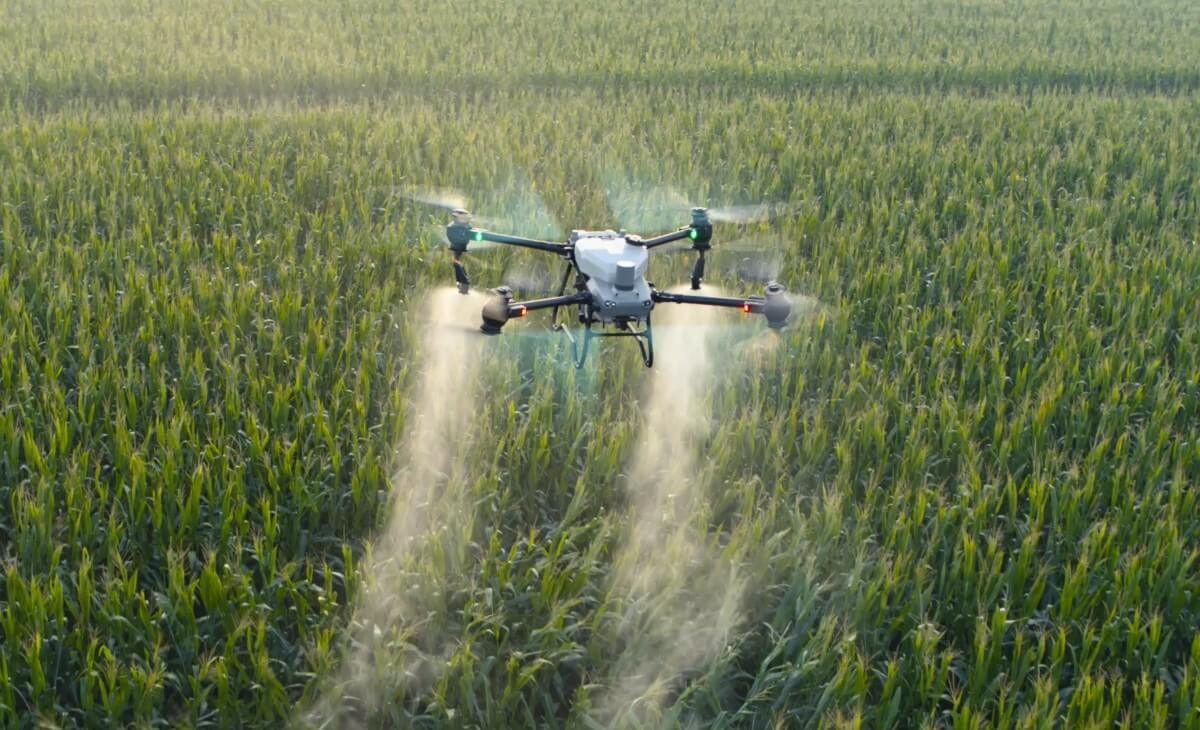
Drone granular spreading is the newer option. A spreader-equipped drone stages off a truck at the field edge, takes off from the headland, flies a programmed pattern in much narrower swaths at much lower speed, and lands beside the loader to refill.
Both are aerial application. They are not substitutes on the same field. The comparison that matters is not which machine is better in the abstract — it is which one your specific fields, product volume, and calendar actually suit. On a big open half section there is no real argument, and on a broken eighty acres ringed by powerlines and bush there is no real argument either. They just point opposite ways.
This is about granular work: dry fertilizer, cover-crop seed, and spot spreading. That is the everyday legal drone service in Canada today and the honest place to make the comparison.
Who It's For
Farms and applicators choosing between two ways of getting dry product on ground a floater cannot travel.
That is usually one of three situations. Wet or soft fields where ground equipment would rut, standing crop too tall for a floater to enter without damage, or a calendar where the uptake window is closing faster than ground equipment can cover the acres. In all three the choice narrows to air, and then the question becomes which kind.
It also applies if you already use a custom aerial applicator and are wondering whether a drone would do anything for you. Often the answer is yes but not on the same fields — the value is in the parcels the plane never wanted anyway.
If you have not yet ruled out ground application, start there instead. The floater comparison covers that decision, and on dry, drivable, open ground a floater is usually still the cheapest pass available.
How It Works
Throughput is the aeroplane's argument and it is a strong one. A loaded ag plane covers dramatically more ground per hour than any drone, and the gap is not close. It flies far wider swaths at far higher speed and carries a payload measured in a scale no multirotor approaches. For reference at the other end, the site's own ROI calculator works from 65 acres per hour for the largest Agras platform. An aircraft's figure lives in a different bracket entirely.
So if the problem statement is "a very large number of acres has to be covered before the weather turns," the aircraft wins on arithmetic alone and no amount of enthusiasm about drones changes it. Be honest about that up front, because a drone operator who pretends otherwise is not worth hiring.
Staging and ferry distance is the drone's argument. An aircraft needs a suitable strip or landing site and a loading setup, and every minute spent flying between that site and your field is a minute not spent applying product. When the staging site is close and the acres are many, that overhead disappears into the job. When the field is far from any strip, or the job is small, the ferry becomes a large share of the work.
A drone has almost no ferry. The truck parks on the headland, the aircraft takes off within sight of the work, and the round trip to reload is measured in metres. That is why a drone can serve a single isolated quarter economically when getting an aircraft there would cost more in positioning than in application.
Field size and shape is where the two genuinely diverge. An aeroplane is efficient in proportion to how much uninterrupted straight line it gets. Long runs in open country are ideal. Turnarounds are dead time, so a field that is all corners burns the advantage away.
Central Alberta parkland is not ideal country for that. Quarters get broken up by sloughs, bush margins, shelterbelts, creek crossings, and yard sites, and the resulting shapes have more edge than area. A drone does not care: it flies the boundary you give it, turns in its own length, and works a twenty-acre irregular piece with the same efficiency per acre as a square one.
Obstacles decide more jobs than people expect. Powerlines, pivots, yard sites, wind turbines, treed margins, and tight approaches all constrain a fixed-wing pass and some of them rule it out. A helicopter handles a lot of this better than a plane does, which is part of why helicopter time costs what it costs.
A drone flies low and slow with obstacle sensing, holds position, and works right up to a shelterbelt or around a pivot point. On a field where the awkward ground is a meaningful share of the acres rather than a rounding error, that difference is the whole job.
Minimum acres, and the small-field reality. Both services carry minimums, because mobilising anything has a fixed cost that does not care about your acre count. The aircraft's minimum is larger, and reasonably so — positioning an aeroplane and a loading operation is a bigger commitment than driving a truck to a headland.
The practical consequence: there is a band of small and scattered parcels that a custom aerial applicator will decline or price as a favour, and those parcels are straightforwardly normal work for a drone. If your farm is one home block plus five outlying pieces in three municipalities, that pattern matters more to your total cost than the per-acre rate does. The quote article covers how mobilisation gets counted.
Prescription resolution, stated fairly. Variable-rate application is not a drone-only capability, and anyone implying that is overselling. Modern ag aircraft can and do vary rate across a field.
The honest difference is achievable resolution. Zone resolution is bounded by swath width and ground speed: a wide, fast swath cannot change rate over a short distance, while a narrow, slow one can. So a prescription map with small management zones — the kind that comes out of NDVI work and zone soil sampling on variable parkland ground — is honoured more closely by a drone. On a field whose real variation is broad and gradual, the aircraft's resolution is entirely adequate and the distinction is academic.
Calibration is a question for both. A spreader's spec-sheet swath is not the swath your product throws, whichever machine is throwing it. Prill size, product density, rate, and height all move the deposition curve, which is why a pan test is what sets the effective swath actually flown. Ask either operator whether they calibrate for your specific product.
Scheduling is two different queues. In peak season a good custom aerial applicator is booked solid, and that is not a criticism — it is what being good looks like. But it means your place in the line is set by everyone else's timing needs as well as yours, and the weather days that suit your field suit every other field too.
Drone capacity is a separate queue with different bottlenecks. Sometimes that means a drone can get to your field in the window where the plane cannot, and that is a scheduling advantage rather than a technical one. On a top-dress pass where hitting the uptake window is the entire point, availability can outweigh throughput, which is the same logic covered in the wet ground and tall crop article.
Documentation. Both should return a record. A drone pass produces a georeferenced as-applied map as a by-product of how it flies, showing where product landed at what rate on what date. Aircraft record coverage too; what varies is the format you get it in and how quickly. Either way, ask what the deliverable is and insist it is named in the quote, because that file is your documentation for a program claim and your baseline for next year.
Authorization, for both, and the pesticide question kept separate. A custom aerial applicator operates licensed commercial aircraft with certified pilots under a long-established framework. A drone dispensing operation in Canada requires a Transport Canada SFOC that names the aircraft and the pilots, plus current RPAS pilot certification and liability insurance. Ask to see the relevant paperwork from whoever you hire. It is a routine request.
Granular fertilizer and seed spreading is the everyday legal drone service and the subject of this comparison. Pesticide application sits under a narrower and newer pathway: in June 2026 Health Canada's PMRA issued an interim Letter of No Objection permitting drone application of pesticides already registered for conventional aerial application, under those label directions, where the registrant has not opted out. Transport Canada authorization and provincial applicator licensing still apply, and products without aerial label directions are not covered. Custom aerial applicators have long operated under the conventional aerial registrations that pathway refers back to, so on a spray job the comparison is a different one with different licensing questions.
The decision table
| If this describes your job | The better fit |
|---|---|
| Large contiguous acres, open country, long straight runs | Custom aerial applicator |
| A very large area that must be covered in one short window | Custom aerial applicator |
| High product volume at a heavy rate over many acres | Custom aerial applicator |
| Fields close to a suitable strip or staging site | Custom aerial applicator |
| Small, broken, or irregular parcels with more edge than area | Drone |
| Powerlines, pivots, yard sites, shelterbelts, tight approaches | Drone |
| Isolated fields far from any staging site | Drone |
| Below an aircraft's practical minimum acres | Drone |
| A fine-zone prescription from NDVI and zone soil sampling | Drone |
| The window is now and the aircraft is booked | Drone |
| Dry, drivable, open ground with time to spare | Neither — use a floater |
On cost. The site's published reference points are the Alberta custom application range of roughly 10 to 15 dollars per acre and a drone operating cost of about 4.50 dollars per acre in the ROI calculator. Those are reference points, not a quote for your field, and they are not directly comparable to a custom aerial rate for a different product at a different volume.
The more useful observation is that on the acres where each method is clearly the right tool, cost is rarely what decides it. Nobody flies a drone over a wide-open half section because it is cheaper, and nobody mobilises an aeroplane for twenty-two broken acres beside a yard site because it is cheaper. Access, timing, and field shape do the deciding, and the cost follows the choice rather than driving it.
Key Dates
- Custom air wins:Large contiguous acres, open country, one short window
- Drone wins:Small, broken, obstructed, or isolated parcels
- Ferry distance:Aircraft overhead per job; almost none for a drone
- Prescription resolution:Bounded by swath width and ground speed
- Calibration:Pan test for your product, from either operator
- Published cost reference:10 to 15 dollars per acre custom rate in Alberta
How UAV AG Can Help
How UAV AG approaches this comparison when you call:
- →We will tell you when a custom aerial applicator is the better tool for your acres, and why.
- →We scope by field shape, obstacle count, parcel spread, and product volume — not by total acres alone.
- →Small, broken, and outlying parcels are normal work for us rather than a favour.
- →Fine-zone prescriptions get flown at the resolution the effective swath can actually honour, and we tell you what that is before the pass.
- →A pan test for your specific product and rate sets the swath we fly.
- →A georeferenced as-applied record comes back after the pass for your files and program documentation.
- →Current SFOC, RPAS pilot certification, and liability insurance available to view on request.
A Note From Us
Framing this as a rivalry would be a mistake, and it is the framing most of the internet reaches for.
The plainest way to see it: a custom aerial applicator is a volume machine and a drone is an access machine. When the constraint is how many acres can be covered before the weather turns, volume wins. When the constraint is whether the acres can be reached at all — because the field is small, the shape is awkward, the powerline runs through the middle, or nobody will mobilise an aircraft for one isolated quarter — access wins. Those are different constraints and most farms have both.
The operations that end up happiest tend to use both, on the fields each suits. The big open ground goes to the plane. The broken parkland quarters, the pieces beside the yard, the outlying parcels, and the fine-zone prescriptions go to the drone. Nobody has to be wrong about anything.
If you already have a custom aerial applicator you are happy with, keep them. Bring us the acres they would rather not have, and tell us what your fields actually look like rather than how many of them there are. Shape, obstacles, and spread tell us more about the right answer than the acre count does.
Frequently asked questions
Is a drone faster than a plane for spreading fertilizer?
No, and it is not close. A loaded ag plane flies far wider swaths at far higher speed with a much larger payload, so on acres per hour it wins decisively. For reference at the other end of the scale, the site’s own ROI calculator works from 65 acres per hour for the largest Agras platform. Where a drone gains time back is in what it does not have to do — no ferry to a strip, no positioning of a loading operation, and no dead time in turnarounds on a broken field.
When is a custom aerial applicator clearly the better choice?
When the acres are large and contiguous, the country is open enough for long straight runs, the product volume is high, and the whole job has to happen inside one short weather window. Fields close to a suitable strip strengthen the case further because ferry overhead shrinks. In that situation the arithmetic decides it and no drone operator should pretend otherwise.
Why would I use a drone instead of an aeroplane?
Because of access rather than speed. Small, broken, or irregular parcels with more edge than area, fields wrapped in powerlines, pivots, shelterbelts, or yard sites, isolated quarters far from any staging site, acreages below an aircraft’s practical minimum, and fine-zone prescriptions all favour a drone. It stages off a truck on the headland, turns in its own length, and works right up to an obstacle.
Can a custom aerial applicator fly a variable-rate prescription?
Yes. Variable rate is not a drone-only capability and modern ag aircraft do vary rate across a field. The honest difference is achievable resolution, since a wide fast swath cannot change rate over a short distance. Broad, gradual field variation is handled perfectly well from an aircraft; small management zones from NDVI work and zone soil sampling are honoured more closely by a narrower, slower swath.
Do aerial applicators have a minimum number of acres?
Generally yes, and larger than a drone’s, because positioning an aircraft and a loading operation is a bigger fixed commitment than driving a truck to a field edge. That creates a real band of small and scattered parcels that a custom applicator will decline or price as an accommodation. Those same parcels are routine work for a drone, which is why scattered farms often end up using both services.
Is it cheaper to use a drone or a custom aerial applicator?
On the acres where each is clearly the right tool, cost is usually not what decides it. The site’s published reference points are an Alberta custom application range of roughly 10 to 15 dollars per acre and a drone operating cost of about 4.50 dollars per acre in the ROI calculator, and those are reference points rather than quotes for your field. Access, field shape, and timing normally decide the method, and the cost follows that choice.
Can I use both a drone and an aerial applicator on the same farm?
That is often the best answer and it is common. Send the large open ground to the aircraft, where volume is the constraint, and send the broken parkland quarters, the pieces next to the yard, the outlying parcels, and the fine-zone prescriptions to the drone, where access is the constraint. Most farms have both kinds of field, so using one machine for everything means accepting a compromise somewhere.
What authorization should I ask an aerial operator for?
On the conventional aerial side, licensed commercial aircraft operation with certified pilots under the long-established framework for that work. On the drone side, a Transport Canada SFOC that names the aircraft and the pilots who will fly your field, current RPAS pilot certification for those pilots, and a certificate of liability insurance. Asking either operator is routine, and anyone working regularly for farms will have the paperwork ready.
Does this comparison apply to spraying as well as spreading?
Not directly, because the regulatory position differs. Granular fertilizer and seed spreading is the everyday legal drone service in Canada and the subject of this comparison. For pesticides, PMRA issued an interim Letter of No Objection in June 2026 permitting drone application of products already registered for conventional aerial application, under those label directions and where the registrant has not opted out, with Transport Canada authorization and provincial applicator licensing still applying. Custom aerial applicators have long worked under the conventional aerial registrations that pathway refers back to, so a spray comparison carries licensing questions a granular one does not.