October 14, 2026
Documenting a Hail, Frost, or Flood Claim With Drone Imagery
The adjuster decides the claim. What you control is how well the damage was recorded before the field moved on, and whether the extent is a measured number or an estimate from the truck window. A mapping flight in the right week is the difference between the two.
What It Is
A documentation flight. Not an assessment of your loss, not a second opinion on the adjuster, and not a claim. A record of what the field looked like, where the damage was, and how far it extended, made on a known date and in a form somebody else can measure.
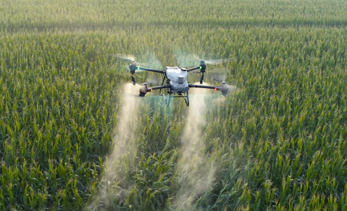
Mechanically it is an ordinary mapping mission. The field is flown in a grid, the overlapping photos are processed into a georeferenced orthomosaic, and because every pixel on that image carries a real coordinate, an area traced on it is an area on the ground. Where the damage pattern shows up better in vigour than in colour, a multispectral pass adds an NDVI layer over the same geometry.
The value is not the picture. It is that the extent stops being an opinion. Twenty-two acres traced on a measurable image is a figure that holds up when someone else checks it. "Maybe twenty acres down in the northwest" is a guess made standing at a field edge looking across at ground you cannot see all of, and everyone in the conversation knows it.
UAV AG runs this as hail damage assessment and frost damage assessment, and flood and drown-out work goes through the same field mapping process.
Who It's For
Anyone who has just had a storm go through and is about to have a conversation about it.
The clearest case is a field where the damage is uneven. If a quarter is uniformly flattened, extent is not in dispute and nobody needs an image to agree on it. The arguments happen on fields where a band went through, or where three separate patches took it and the rest is fine, or where the worst of it sits half a mile back from the only road you can see the field from.
It applies equally to anyone who farms rented ground and has to tell a landlord what happened, anyone splitting a crop share, and anyone who simply wants their own record of a bad year that is better than memory and a few phone photos.
It is also worth it on the fields where you expect to be fine. A flight showing the damage was limited to eleven acres is a useful document when the alternative is an unresolved impression that the whole quarter got hit.
One group this is not for: anyone hoping imagery will overturn an adjuster's yield call. It will not, and that is covered plainly below.
How It Works
Timing is the part that goes wrong most often, and it is unforgiving. The field starts hiding the evidence almost immediately, and each damage type hides it differently.
Hail leaves the clearest short-term record: stripped leaf area, bruised and broken stems, defoliated strips, and a pattern that often runs as a distinct band across the field. In a crop with growing left in it, that record degrades as the plant recovers, and the visible pattern can soften within weeks. The useful flight is after it is safe to fly and while the pattern is still legible.
Frost is slower to appear and the mistake runs the other way. Damage that is not obvious the morning after can be plain several days later once the affected tissue has actually died back. Flying too early on a frost event can under-record it, which is why the sensible approach is to wait for the field to declare itself and then fly.
Flood and drown-out behave differently again. Standing water is unambiguous and worth recording while it is there, but the number that usually matters is the acres that drowned out, which only becomes clear after the water has gone and the crop has failed to come back. Two flights, one with water and one after, tell a story that neither tells alone.
Across all three: check your policy's notification requirement first and do not let a flight delay it. Reporting the event is a deadline set by your insurer, and documentation is something you add to a reported claim rather than a substitute for reporting it. In Alberta, production insurance is administered through AFSC, and the notification terms are theirs, in your policy, not something to infer from an article.
What a claim conversation actually needs. Four things, in this order.
Extent, as area. Which acres, where, and how many. This is the part a measured orthomosaic answers better than anything else available to you.
Date. An image is only evidence if it is tied to a day. Flight date should be stated and consistent with the event, which is also why a flight six weeks later is a much weaker document than the same flight in the right week.
Field identity. Legal land description, the field as you and the insurer both name it, and a boundary that matches the farmed edge rather than the title line. A beautiful map of an unidentified field is not useful to anybody.
Pattern. Whether damage runs as a band, as scattered patches, along a low area, or across the whole field, because the pattern is what connects the damage to the event. Hail bands look like hail. Drown-out follows the low ground. Frost tends to sit in hollows and exposed ground.
Measuring rather than estimating. On a georeferenced orthomosaic, the damaged area is traced and the area is read off. That sounds trivial and it replaces the single weakest number in most claim conversations.
Two things make that measurement trustworthy, and they are separate questions worth asking of whoever flies. Resolution, which is ground sample distance and determines whether you can see the edge of the damage. And positional accuracy, which is set by RTK positioning and, where the result has to tie to a benchmark, by surveyed ground control points. A fine image that sits in the wrong place measures the right acres in the wrong location.
Where multispectral earns its place. Sometimes damage is obvious in a normal photo and nothing further is needed. Sometimes the visible crop looks battered more or less everywhere while the actual severity varies a great deal, and a vigour layer separates the ground that is recovering from the ground that is not. Frost and early-season damage are common cases, as is hail in a crop that has partly grown through it.
The honest limit: a vigour index shows that plants are performing differently, not why. It will not distinguish hail injury from disease, nutrient stress, or a drowned patch on its own. The pattern and the known event are what make the interpretation, and in that sense it works like any other NDVI scouting layer.
Repeat flights are where this gets strong. One flight is a snapshot. The same field flown shortly after the event and again a few weeks later shows whether a patch recovered, held, or kept going backwards, which is a question nobody can answer from a single visit.
This only works if both flights are positioned consistently, because two images compared against each other are only meaningful when they are genuinely in the same place. Ask for that explicitly if you expect to compare dates.
A pre-season flight is the version almost nobody does. A clean baseline map of a field in a normal week is cheap documentation and makes any later claim conversation easier, because the comparison stops being damaged crop against your description of what it used to be.
What this cannot do, stated plainly. Drone imagery does not determine your loss, does not set a yield, and does not replace an adjuster. Yield loss in a damaged crop is assessed by established methods on the ground, including counts and inspections that no aerial sensor performs. An image cannot tell you bushels.
It also cannot prove a cause by itself, and it cannot prove when the damage happened beyond the date it was flown. What it does is make the extent, the location, and the pattern specific and checkable, and arrive at the conversation with facts already in a measurable form.
Do not fly before it is safe or allowed. A storm is often not finished, and a wet field with downed powerlines is not a place to be setting up. Flight operations still need airspace compliance, a current certificated pilot, and visual line of sight, and none of that bends because the circumstances are urgent.
The three damage types side by side
| Damage type | When the record is clearest | What imagery documents well |
|---|---|---|
| Hail | After it is safe to fly, while the band is still legible | Stripped and defoliated bands, extent and location of the swath |
| Frost | Several days later, once affected tissue has died back | Patchy and low-ground severity, extent that was not visible on day one |
| Flood, standing water | While the water is on the field | Water extent and which acres are under it |
| Flood, drown-out | After the water leaves and the crop fails to return | Final drowned-out acres as a measured area |
| Any of the above, recovery | A second flight a few weeks later | Whether the patch recovered, held, or worsened |
Key Dates
- First priority after an event:Report it on your policy terms, before arranging any flight
- Hail flight window:As soon as it is safe, while the band is still legible
- Frost flight window:Several days after, once tissue has died back
- Drown-out acres:Measured after the water leaves, not while it is standing
- Key deliverable:Georeferenced orthomosaic you can measure acres on
- Strongest version:A second flight weeks later to show recovery or not
How UAV AG Can Help
What UAV AG does on a damage documentation flight:
- →We tell you to report the event on your policy terms first, and we do not position a flight as a substitute for that.
- →Flights are scheduled to the damage type, because the right week for frost is not the right week for hail.
- →A georeferenced orthomosaic comes back with the damaged area traced and the acres measured, not estimated.
- →Multispectral is added when severity varies more than the visible crop suggests, and left off when a normal image already answers it.
- →Field identity goes on the deliverable: legal land description and a boundary traced to the farmed edge.
- →Repeat flights are positioned consistently so the two dates can genuinely be compared.
- →We do not assess your yield loss or argue with your adjuster, and we will say so on the call.
- →Current SFOC, RPAS pilot certification, and liability insurance available to view on request.
A Note From Us
The uncomfortable truth about damage claims is that the weakest number in the conversation is usually the one the farmer supplied, and not because anyone is being dishonest. Standing at a field edge looking across a quarter you cannot see all of, after a week you would rather not have had, is a terrible position from which to estimate acres. Everybody knows it, which is why that number gets treated as soft.
A measured figure changes the texture of the conversation rather than the outcome of it. The adjuster still adjusts. What goes away is the part where the extent itself is up for debate, and in our experience that is most of the friction.
The other thing worth saying: the flights people regret are the ones they did not book in the right week. Imagery three days after a hail event and imagery six weeks later are not the same document, and no processing recovers what the crop has since grown over. If a storm has been through, the decision is better made now and quickly than carefully and late.
And if nothing has happened yet, the cheapest useful thing available is a clean baseline map of your worst fields in a normal week.
Frequently asked questions
Will drone imagery get me a bigger insurance payout?
That is not what it does and it would be dishonest to sell it that way. The adjuster assesses the loss using established on-the-ground methods, including counts and inspections no aerial sensor performs, and an image cannot tell anyone bushels. What imagery changes is that the extent, the location, and the pattern of the damage become measured and checkable rather than estimated, which usually removes the part of the conversation where the affected area itself is in dispute.
How soon after a hailstorm should the field be flown?
As soon as it is safe to be out there and the system has genuinely passed. Hail leaves its clearest record immediately, as stripped leaf area, broken stems, and defoliated strips that often run as a distinct band, and in a crop with growing left in it that pattern softens over the following weeks as the plant recovers. Imagery three days after and imagery six weeks after are not the same document.
Why wait a few days to fly a frost event?
Because frost damage declares itself slowly. Injury that is not obvious the morning after can be plain several days later once the affected tissue has actually died back, so an early flight tends to under-record the extent. The sensible approach is to let the field show what it is going to show and then map it, which is the opposite of the advice for hail.
What does an adjuster actually need from me?
Four things, and imagery helps most with the first. Extent as an area, meaning which acres and how many. A date the record is tied to. Field identity, including legal land description and a boundary matching the farmed edge rather than the title line. And the damage pattern, because a hail band, low-ground drown-out, and frost sitting in hollows each look like what caused them. Report the event on your policy terms regardless of what documentation you gather.
Can I just use phone photos from the truck?
They are better than nothing and worth taking, but they cannot be measured. A phone photo shows a corner looks poor; it does not establish how many acres are affected or where the boundary of the damage sits, because a handheld photo has no scale and no coordinates. The reason a mapping flight is different is that every pixel of the orthomosaic carries a real position, so an area traced on it is an area on the ground.
How do I document drowned-out acres?
Usually with two flights. Standing water is worth recording while it is on the field because its extent is unambiguous, but the number that normally matters is the acres that drowned out, and that only becomes clear after the water has gone and the crop has failed to come back. Flying both stages gives a record that neither stage provides alone, and the final measurement comes off the later flight.
Does NDVI prove the damage was caused by hail or frost?
No. A vigour index shows that plants are performing differently from one another, not why, and on its own it cannot separate storm injury from disease, nutrient stress, or a wet hole. The interpretation comes from the pattern combined with a known event: a band across the field after a hailstorm, severity concentrated in hollows after a frost. The layer is useful because it reveals severity the visible crop hides, not because it identifies a cause.
Should I fly the whole field or only the damaged part?
The whole field. Extent only means anything against a denominator, so the undamaged ground needs to be in the same image as the damaged ground. Mapping only the bad patch produces an image that cannot show what share of the field is affected or how the pattern sits relative to the rest of it, which is exactly what the conversation is about.
Is it worth mapping a field before anything goes wrong?
It is the cheapest useful documentation available and almost nobody does it. A clean baseline map of a field in a normal week means any later claim conversation compares damaged crop against a measured record rather than against your description of what the field used to look like. It is most worth doing on the fields that have historically given you trouble.
Can you fly immediately after a storm?
Only once it is actually safe and legal, and that is not always the same day. Storm systems are often not finished, a wet field with downed powerlines is not somewhere to be setting up equipment, and flight operations still require airspace compliance, a current certificated RPAS pilot, and visual line of sight. Urgency does not relax any of those, so the honest answer is as soon as possible within them.